Introduction
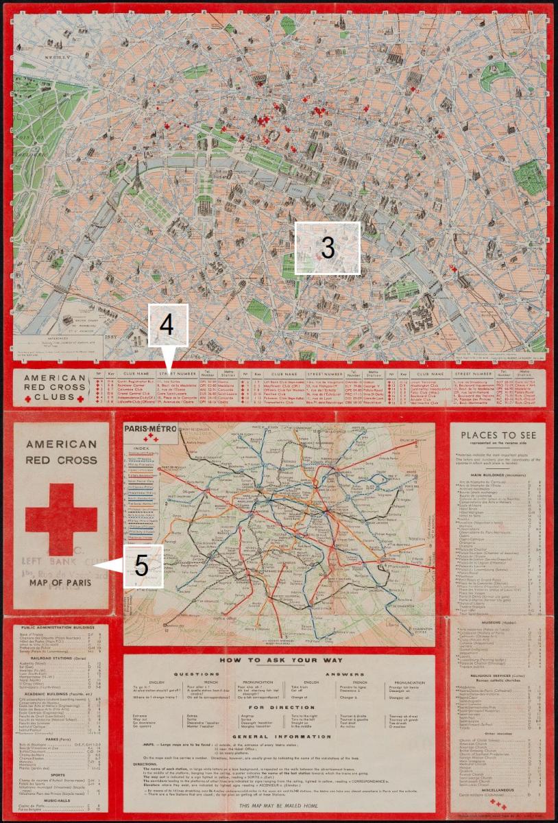 Figure 1. American Red Cross folded pocket guide, color lithograph, single sided map printed on blank verso of repurposed c. 1914 German language map of Dundalk, Ireland. Blondel La Rougery, Paris copyright 1944. See also Figure 2, next page.
There are many ways to read a map. One of my favorites is to discover something in the map that was not necessarily drawn as a principal feature or intended as the subject of the map itself but which in fact once identified reveals another major theme of the map. This element might be the map publication date, or an image, or an unlabeled feature or a fragment of text. This revealed theme might arise from the map itself as if the map were a kind of hologram that when tipped to its side shows a competing image. This essay is about how in reading a map we might look for such clues, and in particular how we might do so where the subject matter of a map is a city or town, or urbanization itself.
This essay is an exercise about critical reading. In keeping with the theme of this edition of the Calafia Journal, for this four-part essay series I have chosen different kinds of town or city maps (American) published or authored in the 19th and 20th c. that I have studied in the past few years.1 My research into each of these maps began with a focus on each work's art, symbolism, geography, author and explicit themes. The discovery in each instance was that hiding in plain sight was at least one feature of each map that also revealed an unanticipated story. Looking at an antique or contemporary map for camouflaged themes intrigues me for a variety of reasons. One reason is that it provides motivation to read a map deeply. Another reason is that looking for complexity in the art of each map sharpens one's eye for discerning persisting themes of American thought and culture. This kind of critical thinking eschews formulas, or ideology and permits the creative pleasure of wondering why. An antique or historic map thus revealed becomes as contemporary as the ideas it embodies.
The American Red Cross Map of Paris (1944)2 (Fig. 1) is a small, colorful folding pocket guide on one sheet published in Paris in 1944 by the American Red Cross. American G.I.'s and the Allies entered Paris on August 19, 1944 through August 25, 1944 to liberate Paris from Nazi German occupation. On August 25 Paris was liberated, and almost immediately this map was distributed by the American Red Cross to American and allied troops, which it continued to do through 1945.3 Paris after its liberation became a U.S. military leave center that relied on Red Cross Clubs operated at the request of the United States government by the American Red Cross for the American armed forces in the European theatre.4 The American Red Cross acquired seventeen hotels (with staff) in Paris with a total of approximately 8,000 beds to create these clubs. By some accounts, there were throughout this period, in constant arrival or exit, over 12,000 American soldiers on leave on a two or three day pass assigned to an American Red Cross club in Paris. They arrived by train, truck or car. This small American Red Cross Map of Paris (Red Cross Map) was there to greet each service person and provide directions to his or her American Red Cross Club for lodging, meals and social life. Thus this 1944 map is a Paris city guide, an American military personnel guide and an extension of American society at home.
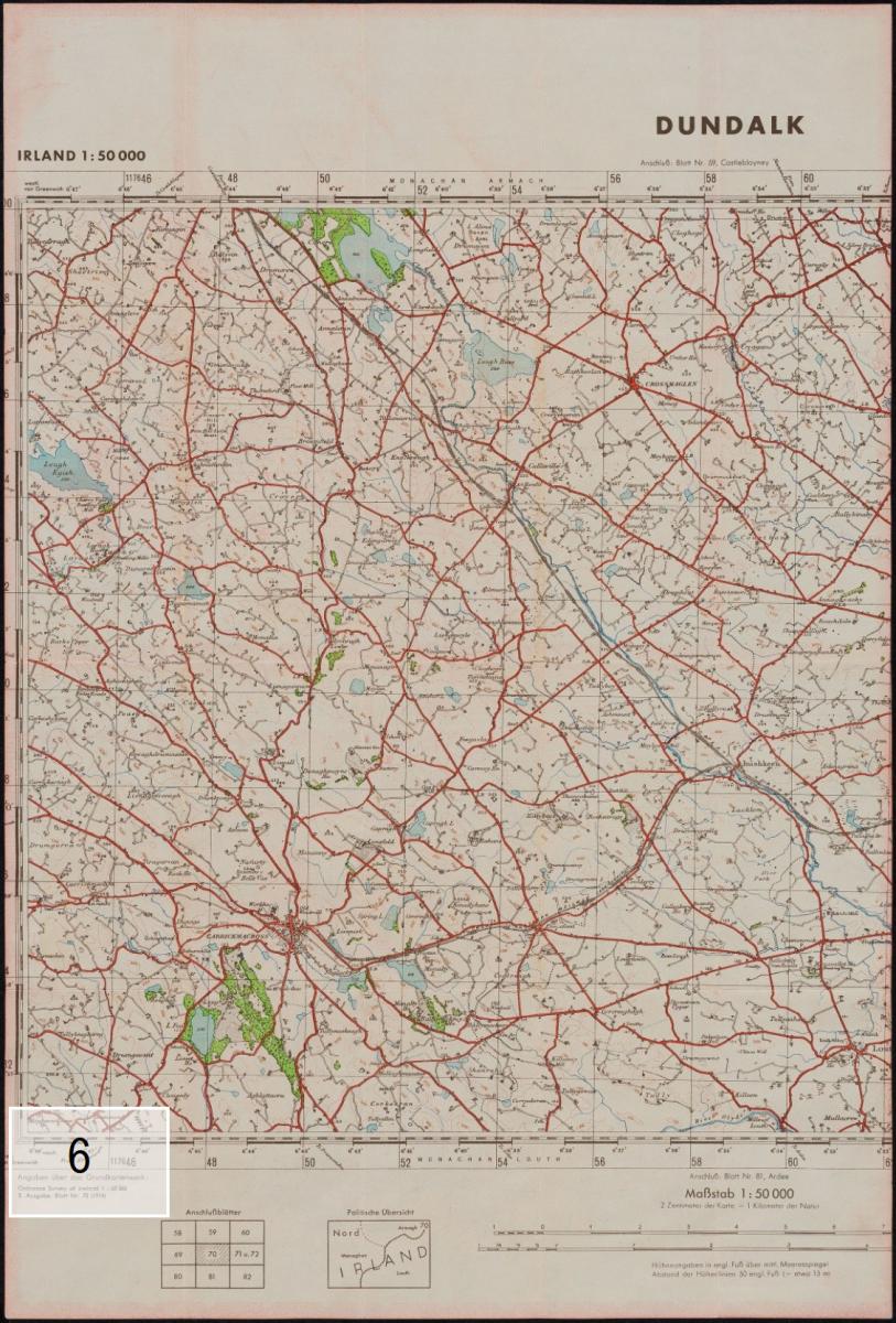 Figure 2. Verso of American Red Cross pocket guide—see Fig. 1.
The color and motif of the map identify it immediately as belonging to the American Red Cross: the organization's large red cross logo is the most prominent feature on the cover5, the map sheet is framed in the same distinctive red as the map cover's logo, and appearing on the map of central Paris are 18 small, numbered Red Cross logos, one identifying the Registration Bureau and the seventeen others each identifying the location of an American Red Cross Club. The particulars of each American Red Cross Club are printed in red in a wide, framed chart placed just below the Paris pictorial map. Even the Paris Métro map has three small Red Cross logos, evocative of the French fleur-de-lis. The map's printer and copyright holder "Blondel La Rougery, Paris 1944" appears in the lower right margin of the map along with the admonition that the map may not be reproduced "Reproduction, même partielle, interdite."
The American Red Cross designed this map for the American service members in its care. We may therefore read this map through the eyes of these intended map owners as well as through those of the American Red Cross itself. The Red Cross Map place names are printed in French and the many map tables are printed in French and English. Our reading of the map benefits from two kinds of scans. First, to enjoy the pictorial map of Paris with its fine details of palaces, formal gardens, cathedrals and historic monuments. Second, to parse the role of the map in the hands of the American service members on leave in Paris and also consider how this map reveals matters not pertaining to Paris at all.
What can the style of this map tell us? Based on its style, paper, and printing technique the Red Cross Map looks like a 20th century map AND suspending disbelief we might readily file this title under 20th c. "tourist map." And in some respects it is. The pictorial nature of the Paris map, the bird's eye view of fine, historic architecture, large parks, and Paris' distinct neighborhoods shows Paris from the Middle Ages to the 19th century within a preserved urban plan. All of this is conveniently laid out on one small sheet for an immediate grasp of the city form and is readable while sitting on a train map in hand, or if grabbed at breakfast before heading out to be a tourist. The engaging and functional color scheme of our map uses bright green to identify parks and gardens as landmarks. The Seine is a calm blue arc running under labeled bridges, useful landmarks and Paris city blocks are colored with a soft pink to permit fine black printed street names and numerous place names to be legible. For ease of navigation the Paris map has an alpha numeric border, typical of tourist guide maps. Charts with information about "Places to See" are keyed to the map. The small paper map is also a neat souvenir, foldable in a small envelope, as the map line at the bottom of the sheet suggests - "This Map May Be Mailed Home." There is no price marked on the map—it was given out by the American Red Cross as a public service. Perhaps this also lends a carefree aspect to our ubiquitous map.
The practical content of the Red Cross Map is modeled on a tourist map. The tourist it is tailored for is the WWII American service person in Paris on two-or three-day leave from active duty and who is well met if curious about the city's history, culture and recreation - someone who may never have traveled at all. The American Red Cross also designed this map as an essential guide to housing, meals, entertainment and transportation. The detailed content of the guide is laid out in two maps and several printed tables. The first map, as noted, is a pictorial map of central Paris. The second map is a transportation map showing the Paris Métro, and train stations. Together, the style and content of these maps lead inescapably to the conclusion that the visitor to Paris using this map is at leisure and liberty to take the Paris Métro or to depart Paris from the international train stations to other parts of Europe. The Paris Métro map encourages the reader to explore: "By means of its 14 lines stretching over 86.4 miles underground, 6 miles in the open air and its 348 stations, the Metro can take you almost anywhere in Paris and the suburbs..." Thus the American Red Cross makes its deus ex machina appearance on the map to remove any doubt about how to get from place to place in Paris and reach essential services.
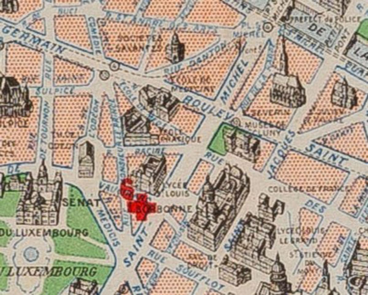 Figure 3. Portion of map showing location of No. 6 "Left Bank Club (Negro-Staffed)”
The Red Cross Map charts provide typical tourist guide tips for an American English speaker abroad. The chart titled "How to Ask Your Way" has English/French questions and answers. Another chart titled "Places to See" lists "the most important places"using an asterisk system to set priorities. Under the heading "Main Buildings (Monuments)" the Tour Eiffel and Arc de triomphe de l'Étoile each have two asterisks. Among "Museums" the Louvre have two as well. "Religious Services" are organized under two sub-headings: "Roman catholic churches" of which seven churches are highlighted with asterisks, notably "**Notre-Dame-de-Paris (Cathedral)"; and "Other churches", such as the Church of Christ Scientist, American Church, Scotland Presbyterian, Main Synagogue, Mosque, Quakers, Russian Church and Saint-Lukes Chapel. If 72 hours was too short a period to visit these places, the pictorial aspect of the map could be read later. All place names in each chart are keyed to an image on this pictorial map.
What cognitive dissonance arises from this 1944 Red Cross Map! Imagine being handed a colorful tourist guide with drawings of fancy little buildings, a summer blue Seine and vast greenswards, gardens and a forest—the Bois de Bologne and Paris' other formal city parks—a scant two months and two and a half weeks after D-Day, the Allied launch of the Normandy Invasion on June 6, 1944 when 156,000 American, British and Canadian troops landed on Normandy beaches and fought their way into France through German fire. No trace to be found on this map of Allied battles that drove Nazi German army units east from Normandy, of ruptured bridges and abandoned military vehicles as shown on certain U.S. regimental pictorial maps, such as those of the U.S. 79th Regiment Division.6 Blondel La Rougery of Paris, the map printer, drew upon a map library of pictorial French tourist maps ready to go, descendants of Turgot's 1739 view of Paris and 19th c. editions with detailed axonometric drawings of every building in central Paris, of the Seine with wooden barques and ornate spires on Notre Dame. The American Red Cross designed its Map of Paris with Blondel to embody an immediate albeit brief resumption of normalcy for its WWII combat clients on leave in Paris.
 Figure 4. Listing of the American Red Cross Clubs in Paris.
The one new "military" element in the Red Cross Map are the symbols and text on the map about the new American Red Cross Central Registration Bureau and seventeen American Red Cross Clubs in Paris. The Club names on the "American Red Cross Clubs" chart (Fig. 4) illustrate the variety of U.S. military personnel in Paris. The small text of this chart uniquely is in red. The small font on this map relays outsized information.
Hiding in plain sight within this "American Red Cross Clubs" chart among club names with literal meaning, history references, and place names are terms with meanings in code. Information in parenthesis following certain club names is a code that left no room for ambiguity, the American Red Cross author's goal and the client's need. For the 1944 American service person the "American Red Cross Clubs" chart was necessary reading as it is for our study of this guide map as we apply the second kind of scan referred to above. These terms confirm that even when they were on leave in Paris as tourists, American service personnel lived and worked in a ranked society, and a racially segregated American army.
It is simple enough to read down the Club list chronologically from No. 0 ("Centr. Registration Bur.") to No.18 ("Montmartre Club") and across each column to learn the club address, telephone number and Paris metro station. Some club names are literal and denote military rank required to enter, others former hotel names, local historic events or individuals. Some club names require additional cues. For example, no.4, the "Independence Club (Of.)" and No. 5 "Lafayette Club (Officers)" are two of three clubs reserved for officers. The terms in parenthesis are an unambiguous cue. No. 15 is "Patio Club (Wac)" the cue in parenthesis addressed to Women's Army Corp personnel. No. 8 "Officers Club for Women"is a self explanatory, literal club name.
By itself on the southern bank of the Seine, No. 6, "Left Bank Club (Negro-Staffed)" at Rue Vaugirard near the Sorbonne (Fig. 3) has a different set of cues than those for clubs designated for service women or ranking military officers. One cue for Club No. 6 is its map location, a historically avant garde neighborhood consisting of the 5th and 6th arrondissement that also includes the Latin Quarter. This unique and solitary geographic club placement was a choice by the American Red Cross and perhaps the U.S. Military command. Certainly the terms in parenthesis on the Red Cross Club Chart for the Left Bank Club, while not immediately obvious as to their full meaning, are not ambiguous about there being a racial distinction to this club. The terms "Negro-Staffed" are meant to denote that this club is for African American U.S. Army men as is Club No. 10, the "Potomac Club (Negro-Staffed)." That a "whites only" term does not appear on the American Red Cross Clubs chart for the fifteen other clubs also reflects an official American Red Cross and U.S. military policy that segregation's cues themselves followed certain rules. The author of the map's club chart and all of the readers of the map's club chart well understood the rules. The male soldiers on leave to visit Paris were coming from a racially segregated army.7 By contract, the women of the Women's Army Corp (WAC) were not. Notably the American all volunteer Stage Door Canteen was open to all.8
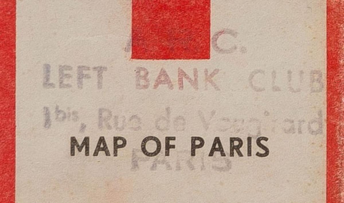 Figure 5. Purple stamp appearing on the author’s copy of the American Red Cross Map of Paris.
A distinguishing feature of our example of the American Red Cross Map of Paris is a large purple ink stamp: "A.R.C. LEFT BANK CLUB 1 bis, Rue de Vaugirard, Paris" on the cover. The ink stamp (Fig. 5) refers to club No. 6 described above. The American Red Cross likely stamped the cover. This map therefore would have been of particular interest to an African American serviceman and may have been brought back to the United States by him at the end of WWII. I do not know if generally Red Cross Map guides had similar ink stamps with the club name on the covers.
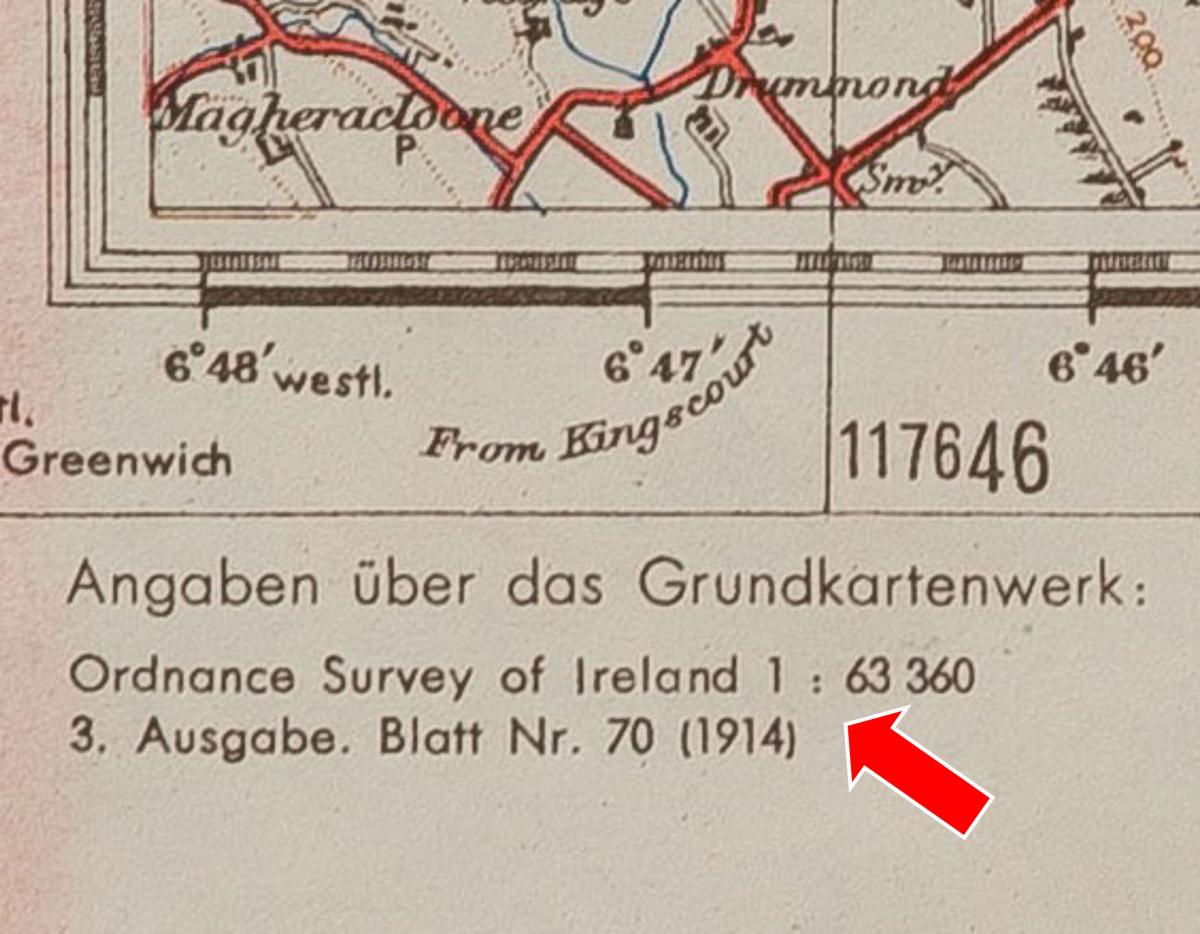 Figure 6. German language notation on verso of Red Cross Map.
There is a final non-Red Cross element that distinguishes our map and offers insights about conditions in Paris after August 25, 1944. The format of our map is designed as a single sided map. Our map was printed in Paris immediately following Paris' liberation and should be understood in the context of 1944 shortages in the French civilian population of food, fuel and medicine. Our example of the Red Cross Map is printed on paper Blondel La Rougery repurposed from its old map print runs and thus illustrates a paper shortage even for a client paying for thousands of maps. Our map is printed on the blank verso of a panel of a German language topographic map (Fig. 2, page 16) section titled "Dundalk" in the top margin, the lower left corner reading "Ordnance Survey of Ireland...Blatt Nr. 70 (1914)." Dundalk, County Louth is on the north east coast of Ireland, just below Northern Ireland. (Fig. 6) I am aware of no connection between 1944 Paris and 1914 Dundalk.
This last feature on the verso of our American Red Cross map sheet challenges the overall premise of the two maps of Paris on the front of the sheet that life and tourism in Paris have returned to normal, and that historic central Paris is the same as it ever was before Nazi German occupation. Blondel de la Rougery likely did not anticipate in the near term needing a map for German speaking customers. Therefore, repurposing blank paper on the back of German text seems logical. The cumulative trauma in Paris of Nazi occupation, the deportation from France to concentration camps and intended genocide of its entire Jewish population, and others, and the ongoing Allied fighting in the WWII European theatre to defeat Nazi Germany are the context for the printing of our map. Thus, hiding in plain sight, on the back of our map is further cartographic proof that this map was printed locally in war-time when certain social and political realities in both the United States and France would dictate not only the imagery and coded text of the American Red Cross Map of Paris, but the paper on which it was printed.
- 1. The six maps in this four-part essay series are: Map of the Town of Ellsworth Hancock Co. Maine from Actual Survey by D.S. Osborn, E.M. Woodford, publ., Philadelphia, 1855 [please see April, 2021 issue.]
- 2. Georgia. Daniel Sturges, Surveyor General of Georgia (manuscript) Certified Survey Plan dated April 21, 1808, Milledgeville, Georgia
- 3. American Red Cross Map of Paris. Blondel La Rougery, Paris 1944
- 4. Seattle Transit System Operation as of May 12 1940.[Seattle, Washington]
