
The Back Room
The Back Room presents both Americana and international materials. This inventory is a selection of rare, scarce and one of a kind materials published in the 18th, 19th and occasionally the 20th century. The Back Room also includes 19th century American wall maps, an area of special interest. The Back Room inventory will be updated frequently.
Displaying 1 - 20 of 91Pages

Hawaiian Government Survey and Hawaii Territory Survey Maps
MAUI HAWAIIAN ISLANDS. 1885.1903.
Hawaiian Government Survey. W.D. Alexander. Surveyor-General.
Primary Triangulation by W.D. Alexander and S.E. Bishop.
Boundaries and Topography by W.D. Alexander, C.J. Lyons, M.D. Monsarrat, F.S. Dodge, S.E. Bishop, E.D. Baldwin and W.R. Lawrence.
Map by F.S. Dodge. [Scale 1:60000] 1885. Brought up to date in 1903 by John M. Donn.
Andrew B. Graham Co., Lithographers, Washington, D.C. [1906]

This unique example of Birds Eye View of Casco Bay: Portland, Maine and Surroundings. c. 1905 was owned and used by Officer Lt. Armstrong as a military "site plan" for the U.S. Army's program to prevent malaria during WWII 1/ at it primary East Coast base, Casco Bay, Maine. The base was both defensive and offensive in its programs throughout WWII.

This finely engraved and hand colored 1823 map Virgin Islands &, is from Fielding Lucas Jr.'s 1823 American A General Atlas Containing Distinct Maps of All the Known Countries in the World, Constructed from the Latest Authority. Various engravers produced the individual maps. Fielding Lucas Jr. was an early and highly successful American map and chart publisher. Fielding Lucas Jr. also engaged in other civic, printing and philanthropic endeavors.
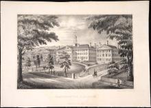
This rare lithograph print is the first state, first edition of DARTMOUTH COLLEGE. printed c.1834-1835 by Nathaniel Currier in New York City where he set up his first lithography shop with a business partner named Adam Stodart in 1834 under the name Stodart & Currier.1/ Currier learned lithography when he was at age 15 apprenticed to Pendleton's Lithography in Boston, the partnership of brothers William S. Pendleton (1795-1879) and John B. Pendleton(1798-1866). Currier moved to New York City in 1834 and by some accounts worked briefly with John B.

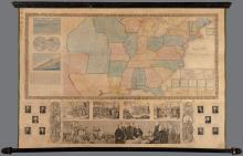
Mitchell's commanding 1845 wall map titled Mitchell's Reference and Distance Map of the United States consists of the titular, primary map of the United States that fills almost the entire 6 foot wide sheet and of a one-quarter sized, inset map titled A General Map of the of the United States with the contiguous British & Mexican Possession of utmost political significance that graphically appears to emerge as the metamorphosis of the United States into its destined coast to coast boundaries. This transcontinental map shows the Republic of Texas with its stovepipe.
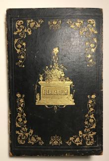
The personal travel diary is written in a fancy, commercially manufactured, bound volume titled HERBARIUM on its front cover that contains approximately forty-one (41) blank, doubled sided, unnumbered, gilt edged pages. Gertrude Holbrook (b.1840-1912) 1/ collected and had mounted dried plant specimens collected as mementoes on each page, accompanied by the date and locale, and her manuscript ink or pencil comments about her activities at that locale. The comments are not scientific or botanical.

This large collection of seventy-six (76) visually exuberant M.I.T. student life posters from 1968 to 1971 were published by the M.I.T. chapter of Alpha Phi Omega (APO) to adorn the infinite corridor and other M.I.T. campus locations, pinned to bulletin boards, walls, doors and other receptive surfaces.
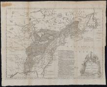
A Map of the British and French Settlements in North America of c. 1755 is an argument in the format of a map whose graphic elements outline the land claim by the British. There are three primary graphic elements of this medium sized map: the map, a column of text and a tiered trophy-like monument decorated with elaborate flowers. First, the map itself illustrates the territory and the competing settlements to which the map title refers.
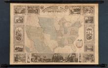
Ensigns & Thayer's Pictorial Map of the United States 1847 was published when all eyes were on the West.1/ This scarce map is a portrait of the United States on the threshold of its complete national borders. Notably this wall map marks the date one year since the outbreak of the Mexican - American War (1846-1848) and the U.S. Congress' vote (1846) to admit the State of Texas, a slave holding state, as the newest American state.
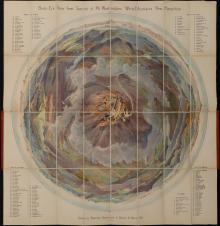
Behold Mount Washington, New Hampshire, as if borne above its peak and above the clouds, the entire atmosphere in pale blue, purple and rose hues of dawn as drawn on stone by Geo. Walker & Co.'s artists for the Bird's Eye View from Summit of Mt. Washington; White Mountains, New Hampshire. Issued by Passenger Department Boston & Maine R.R. (copyright 1902) first edition 1/. The bird's eye view is looking down through the parted clouds on a summer day at human activity, historic buildings and the cog railway.
unique manuscript notations:
inside front cover: iron gall ink owner name "[C-] or [ B-] urleys" (?) 2/
1st free endpaper, front, reversed imprint from inside cover manuscript above
2nd front free endpaper, top, manuscript iron gall ink: "Bot at Vendue 23 S " 3/
title page: top right corner, iron gall ink owner initials and shelf no., "EDW [?] H2LL"
inside rear cover manuscript ink "22/"
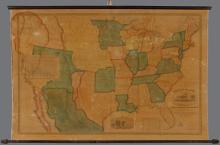
Phelps & Ensign's pictorial wall map Travellers' Guide and Map of the United States 1845 represents the year in which the phrase "America's manifest destiny" first entered the national conversation to explain America's active westward expansion "to overspread the continent" and become a coast to coast nation from the Atlantic to the Pacific Ocean. 1/ This 1845 pictorial wall map presents a large, detailed map of the United States with Texas as its western boundary and only that portion of Mexico that abuts Texas.

This lot of four (4) distinct annual finance and banking titles (1850 in duplicate) published by the Mexican government consists of reports for the years 1830 to 1850 that are scarce, original records relevant to scholarship of Latin American finance and internal Mexican public finance that were published during turbulent times in independent Mexico's early political and fiscal history.

Henry Francis Walling's1/ large scale, and extra large Map of The County of Bristol, Massachusetts, 1858 ("Bristol County Map ") is a simply decorated, topographical, trigonometric survey of Bristol County, Massachusetts presenting the county's south eastern shoreline on Buzzard's Bay, its major 19th c. cities such as Fall River, Taunton and New Bedford and small inland towns that together comprise the southeastern edge of Massachusetts.
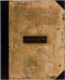
Owner Label on Front Cover: Wm. P. Craighill

This vividly colored Ensign, Thayer & Co. Map of New England 1/was found rolled up and tucked away for safe storage by a family member for future generations, and here it is. The riot of imagery and geometric patterns, original vivid orange outlines and orange, red and green wash are characteristic of certain Ensigns 2/ & Thayer2/ pictorial maps and fully expressed in this remarkable example.
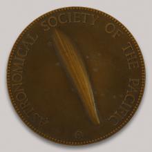
An unknown comet flashes across the night sky. It is August 9, 1932 and Harvard College Observatory researcher Fred L. Whipple saw on a photographic slide this "unexpected comet". For this discovery Professor Fred L. Whipple is awarded the Astronomical Society of the Pacific's Donohoe Comet Medal for 1933, a cast bronze medal bearing the award founder, Joseph A.
This scarce map represents the United States during its ultimate westward territorial expansion and is likely the first edition of Reed & Barber's Map of the United States of America with its Territories & Districts. Including also a part of Upper & Lower Canada and Mexico. 1850. 1/ I have found no records or commentary on this edition, or any recognition that there are two different 1850 editions of Reed & Barber's map.

This first edition of the T. and E.H. Ensign 1/ Map of the United States From the Latest Authorities.1846 with its large inset Map of Texas is a map of ambition. First, the political ambition on December 29, 1845 of the United States Congress to extend the nation coast to coast starting with a vote that day of a majority of both chambers of Congress to annex Texas as the 28th State. Congress knew opening this path required taking substantial Mexico territory all the way to the Pacific Coast.