
The Back Room
The Back Room presents both Americana and international materials. This inventory is a selection of rare, scarce and one of a kind materials published in the 18th, 19th and occasionally the 20th century. The Back Room also includes 19th century American wall maps, an area of special interest. The Back Room inventory will be updated frequently.
Displaying 21 - 40 of 88Pages

This large collection of seventy-six (76) visually exuberant M.I.T. student life posters from 1968 to 1971 were published by the M.I.T. chapter of Alpha Phi Omega (APO) to adorn the infinite corridor and other M.I.T. campus locations, pinned to bulletin boards, walls, doors and other receptive surfaces.
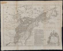
A Map of the British and French Settlements in North America of c. 1755 is an argument in the format of a map whose graphic elements outline the land claim by the British. There are three primary graphic elements of this medium sized map: the map, a column of text and a tiered trophy-like monument decorated with elaborate flowers. First, the map itself illustrates the territory and the competing settlements to which the map title refers.
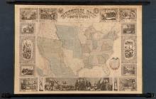
Ensigns & Thayer's Pictorial Map of the United States 1847 was published when all eyes were on the West.1/ This scarce map is a portrait of the United States on the threshold of its complete national borders. Notably this wall map marks the date one year since the outbreak of the Mexican - American War (1846-1848) and the U.S. Congress' vote (1846) to admit the State of Texas, a slave holding state, as the newest American state.

This 17th century map of the Sommer Islands, engraved in Amsterdam and importantly published in England "to be sold by George Humble in Pops-head Alley" is the early, rare edition that lists the names of the island's original English settlers and shows their houses, a castle, a church and other buildings throughout the settled lots. A miniature image of the Bermuda islands appears below the map title block where the title and accompanying text is written in both English and Latin.

This scarce 18th century map, A Map of Virginia and Maryland, 1756, was published in London in at least two editions, of which this is the first. It appeared in a book titled A Compendium of Authentic and Entertaining Voyages, vol. 3, p. 125 and is based on an earlier map by Fry & Jefferson of 1753. Geographic features graphically dominate the map, with the "Blue Ridge Peaks" shown in relief graphically along with the Allagany Mountains.

Printed for the London Magazine, this 18th c. map of the English Province of Pensilvania shows the Province when "The Northern Boundary of Pensilvania is not yet settled" and regions belonging to Native Americans are identified, such as the Delawares, Nanticokes and Tuteloes. English towns are located on the map indicated by a circle. The engraver's "Explanation" only has a symbol for Indian Towns, Roads and Trading Paths. Provincial boundaries are drawn with dotted lines.
This rare color engraving by Filippo Morghens (b. 1730) of the Bay of Naples, plate number 38 as printed in the top right corner of the map, is one of a series of views of the Kingdom of Naples by Morghens that was created in his Naples studio in 1772. Morghens' name appears in the lower right corner of the map. An elaborate decorative cartouche distinguishes the artful map with a figure on one shield, heraldic symbols on the other and a Neapolitan Mastiff in the scene, flanked by an ancient stone pillar bearing Egyptian symbols.

This book is the rare 1781 first edition of The Constitutions of the Several Independent States of America that by Order of Congress dated December 29, 1780 1./ was printed in a limited edition of 200 by Francis Bailey 2./ of Philadelphia as government printer.3./ The book format is new to 18th c. American publishing 4./ this being the first use of a compendium format. The subject matter itself is exceptional, the first publication in book form of the founding documents of the United States of America.
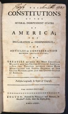
Our distinctive copy of The Constitutions of the Several Independent States 1785 was owned by Baptist Pastor Hezekiah Smith (1737-1805), of the First Baptist Church of Haverhill, Massachusetts (1765-1805) whose American, 18th c. engraved armorial bookplate x/ is attached to the inside front cover. Hezekiah Smith also signs and dates his name in script "Hezekiah Smith's 1785". The book's front first free endpaper is signed "Rebecca Smith's 1805" and she is Hezekiah Smith's daughter (b.
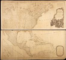
Publisher Robert Sayer's 1786 "A New Map of North America" by Thomas Pownall is "New" because it illustrates the newly established United States of America according to the terms of the Preliminary Articles of Peace of January 20, 1783, that six months later are finalized by the final Peace Treaty of 1783 that concluded America's Revolutionary War with Great Britain./1 This scarce map presents on two 48" engraved map sheets the political paradigm shift of the American Revolution and the newly agreed upon territorial relationships in North America between the governments of the United Stat

The engraver of Jeremiah Dobbs' 1794 New York Cooper's Society Membership Certificate engraves his name "Rollinson Delt. et Sct." This signature compares with William Rollinson's signature on documented American works in 1791, 1792 and 1796.
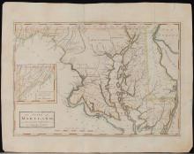
This 18th century map of Maryland is the first published atlas map of the State of Maryland published in America. The copper plate engraving portrays Maryland's topography, networks of natural waterways (at a level of detail from river to creek to marsh and even a beaver dam), main routes, counties, cities and towns as of 1795.

The scene drawn by Edward Savage of Liberty as the Goddess of Youth offering sustenance from her golden goblet to the American Bald Eagle as he descends from backlit clouds captures the moment in American history when the new nation is being born. Drawn in the sky above Liberty and the Bald Eagle, emerging from smoke and clouds is the new American flag with thirteen stars, a cloth liberty cap atop the flagstaff.
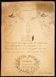
This hand drawn student work, signed and dated inside a wreath of floral branches "ROXBURY Free School Febr. 8th, 1800, Abraham S. Fox Scripsit." is both a tribute and a mourning piece to the recently deceased President George Washington a scant six weeks after the President's death. Abraham S. Fox dedicates this drawing to his teacher "To the Preceptor" in the lower right corner. Perhaps this work was a classroom exercise.

The Georgia Plan (1808) and the Sturges/Bohlen Archive (1795-1808) are a remarkable set of newly discovered historic documents centering on Georgia and Philadelphia that personalize Georgia's complex land accession and land survey history, and highlight major land fraud schemes of 1795 to 1808. Sturges' Georgia Plan (1808) and the Sturges/Bohlen Archive are first person reminders of America's fraught creation myth, and highlight the competing forces of private investment in land, mercan
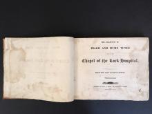
This book is the scarce first American edition of this 18th and early 19th c. music work. The purpose of the first two London editions of this collection of psalms and hymns and of this first American Edition, was with varying success the charitable support of the Chapel of the London Lock Hospital, an English institution that opened in 1747 as the first clinic in London dedicated to the medical care of women afflicted by venereal disease. Later the hospital developed a maternity ward and gynecological services.
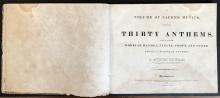
We read in the title page of A Volume of Sacred Musick that its author is "The Late Hon. John Hubbard. Professor of Mathematics and Natural Philosophy in the University of Dartmouth." his academic affiliation in an unusual format that substitutes "Dartmouth University" for the actual name Dartmouth College, given in its 1769 original Charter. Professor John Hubbared (1759-1810) died before publication of his work.
This scarce, early 19th century engraving shows the naval battle at Plattsburgh, New York in 1814, the concluding and decisive American naval victory of the War of 1812 between America and Britain. The battle was momentous. Lake Champlain offered the British Navy a potential naval gateway from Canada into America. Lake Champlain would have provided the British Navy with water access via a short portage to Lake George and further south via the Champlain Canal to the Hudson River.
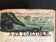
This Album is a six year slice of life along the Connecticut River only 50 years after the American Revolution that reflects contact with America's foremost institutions, America's early 19th c. intellectual activists, educators, abolitionists, free thinkers, and artists - including the deaf painter Augustus Fuller, Catherine E. Beecher, Thomas Gallaudet, religious thinkers and relationships in the personal life of Gratia Denny, an extraordinary individual.

This hand drawn map is signed "Phebe Varney, 1830. Dover Duchess County" on the front. The title of the map is "Africa". The map is hand drawn on thick paper with colored inks and possibly a fine brush. The thickness and opacity of the paper would not have permitted easy tracing and therefore it is most likely the author of the map drew it freehand, perhaps using a grid system (or longitude and latitude lines) to scale up or down a published map or set of maps of Africa. The map appears to be unique.