
The Back Room
The Back Room presents both Americana and international materials. This inventory is a selection of rare, scarce and one of a kind materials published in the 18th, 19th and occasionally the 20th century. The Back Room also includes 19th century American wall maps, an area of special interest. The Back Room inventory will be updated frequently.
Displaying 61 - 80 of 88Pages
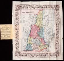
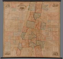
This rare Colton pocket map New Hampshire, copyright 1854 presents a compact and detailed description of New Hampshire at the beginning of railroad expansion, industrialization and the growth of population in New Hampshire's major cities and regions to the north due to railroad access. To make the point, Colton's map presents county population statistics for 1840 and 1850 to quantify the influx of new inhabitants and the considerable growth of households in New Hampshire.
This scarce, large, illustrated wall map of Salisbury & Amesbury, Essex County, Massachusetts, Map of the Towns of Salisbury & Amesbury Essex County, Mass. 1854 presents a challenging visual composition of surveys, architecture and landscape along the mighty Merrimack River and its tributary the Powow River. This portrait of Salisbury and Amesbury in 1854 is drawn to highlight new features in each town.
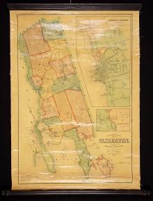
A beautiful example of this scarce Massachusetts town map of 1855 prepared by Henry F. Walling as Superintendent of the State Map. A table at the bottom of the map provides essential history and statistics of Fairhaven. There is a large map inset of Fairhaven and Oxford Villages. The different areas of town are indicated with Roman Numerals. The large scale survey permits detailed description of the coastal terrain, of buildings and their owners and of roads and ways.
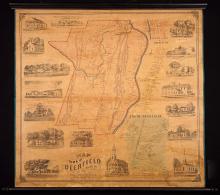
This rare wall map of Deerfield, Massachusetts is a detailed 1855 survey of the town and its villages, an architectural portrait of the fine homes, churches and other establishments in town and a Connecticut River Valley vista that captures the dominant profile of the Connecticut River, its tributary the Deerfield River and the surrounding Pocumtuck hills and mountains. The map and inset maps are drawn at two different scales, both of which permit labeling on the respective map each house or building by name.

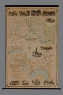
E.M. Woodford’s rare, large scale, illustrated 1855 wall map of Ellsworth, the county seat of Hancock County, Maine, based on the 1854 survey of D.S. Osborn, captures Ellsworth as a thriving town near the height of its industrial strength in shipbuilding and manufacturing. The detailed wall map of Ellsworth presents the civic and geographic character of the 55 year old town. Hancock County, a rural but resource rich region, poured its resources into Ellsworth as the county seat for local consumption and export.

This detailed and decorative wall map of Dartmouth, Massachusetts presents a prosperous and well settled coastal Massachusetts town in 1856. The Map of the Town of Dartmouth shows the town's 27 numbered School Districts and the map is illustrated with six pictorial vignettes, including the J. Cummings Stone Mill, the 1st Congregational Church, B.T. Cummings' Store and Wm. Cummings' House, the Matthews, Meshow & Co.'s Ship Yard, the Apponagansett Bridge and the School House in District No. 10.
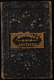
This is a rare pocket map of Kentucky four years before the Civil War. The map is a bright color lithograph, with three inset maps: one in black and white of Falls of Ohio River with major cities on either side of the Ohio River including Louisville, Jeffersonville, the Shipping port Canal, Portland and New Albany; a black and white inset map of Washington, Williamsburg and Clarksburg; and a large color inset map of Lexington in Fayette County with the surrounding counties. A chart on the map lists Steam Boat Routes.
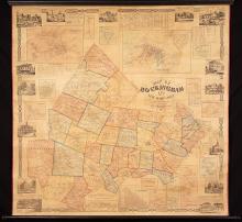
This is the first edition of Chace's survey of Rockingham County drawn from actual surveys at a large scale to permit labeling individual homes, stores, factories and other locations of note. Surrounding the perimeter of the map and joined by decorative bands are 13 pictorial vignettes and two tables. There is a large inset map of Portsmouth City (18 ½" x 12") that includes the Kittery Navy Yard and a large inset map of Exeter Village (15 ½" x 10 ¼") as well as smaller inset maps of each town center in Rockingham County.
The scarce Map of the Town of South Kingstown Washington Co. Rhode Island 1857 surveyed and drawn by Henry F. Walling is a decorative and historical narrative about the Colonial era settling of the Atlantic Coast that concentrates on the founding, surveying and delineation of South Kingstown, the county seat of Washington County, Rhode Island with highlights about its Colonial era residents and the map is a portrait c.1857 of the thriving South Kingstown community.
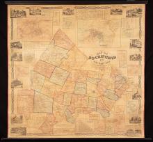
This is the first edition of Chace's Map of Rockingham Co. New Hampshire From Actual Surveys drawn at a large scale to permit labeling individual homes, stores, factories and other locations of note. Surrounding the perimeter of the map and joined by decorative bands are 13 pictorial vignettes and two tables. There is a large inset map of Portsmouth City (18 ½" x 12") that includes the Kittery Navy Yard and a large inset map of Exeter Village (15 ½" x 10 ¼") as well as smaller inset maps of each town center in Rockingham County.
Henry Francis Walling's1/ large scale, Map of the County of Berkshire Massachusetts, 1858 ("County of Berkshire Map ") is a decorated, topographical, trigonometric survey of Berkshire County, Massachusetts presenting the Berkshire Hills and this mountainous region on the westernmost edge of Massachusetts, its rivers, valleys, plains and its prospering towns and institutions at mid-19th century three years before the U.S. Civil War. The northern towns of Berkshire County burst beyond the map's top border.

This large scale, colorful and scarce map of Boston and surrounding towns as surveyed in 1859 captures Boston just before the Civil War. The scale of this map permits a close view of the street level aspect both of Boston and of its neighboring towns as far west as Lexington. The highly developed wharf line of Boston, South Boston, East Boston and the Mystic River are drawn in fine detail. The depths of the Boston Harbor waters are shown and the deep channel into the Central or Long Wharf based on U.S. Coast Surveys.
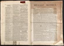
Frederick Douglass (1817-1895) was born a slave in Maryland, escaped to New Bedford, Massachusetts in 1836 and began his career as an abolitionist in 1841 with a speech delivered at an abolitionist convention in Nantucket, Massachusetts. Douglass' first abolitionist newspaper was The North Star commencing December, 1847 in Rochester, New York. Between 1851 and 1858 Douglass had editorial control over a larger merged paper. In 1858 Douglass began Douglass' Monthly, a paper concerned exclusively with abolition of slavery in America.
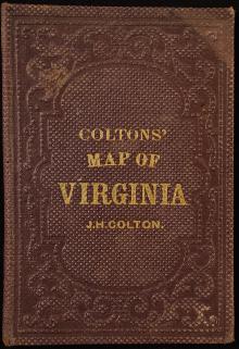
This 1861 Colton pocket map of the State of Virginia is a rare pocket map that shows the State of Virginia in its entirety before the western portion was removed in 1863 for the creation of the state of West Virginia. There are two black and white inset maps: one of Richmond, Henrico Co., Manchester and Springhill, Chesterfield Co. and the other of Norfolk, Portsmouth and Gosport. The Explanations Key on the map shows the symbols for railroads, Common roads, canals, the State Capitol at Richmond, counties, towns, village post offices and depots.
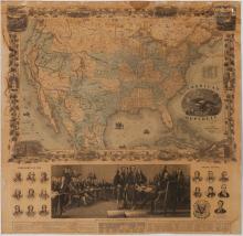
This image rich wall map is an example of pictorial, political and decorative mapmaking. Consisting of two, large joined panels, this wall map functions at several levels. The first is as a detailed, colored map of the continental United States. The second is as a historic and patriotic engraving in the bottom panel that shows the July 4, 1776 Signing of the Declaration of Independence, alluding to John Trumbull's monumental painting hung in the U.S.
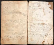
Author (anon.), an American carpenter hired onto the Expedition, sailing on the Bark Clara Bell, January 30, 1865 from New York to Siberia and returning safely November 12, 1867 to his home on Martha's Vineyard, Massachusetts. He does not sign his book.
Manuscript text and illustrations, primarily in pencil
Manuscript pagination pp.1-119 (outbound), pp.1-23 (return) with manuscript table of contents.
Highlights of 19th c. Manuscript Illustrations:
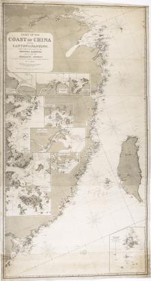
This Admiralty Survey chart describing in great detail the coast of China and all of the coast of Formosa is a rare 19th century, engraved, two toned nautical chart representing new surveys that build on the original survey work done by Captains Collinson and Kellett, and Sir Edward Belcher R.N. between 1840-1850 that for their time provided western navies with some of the earliest nautical surveys of the east Coast of China. In Collinson and Kellett's 1845 survey, also engraved by Isaac Purdy and published by H.
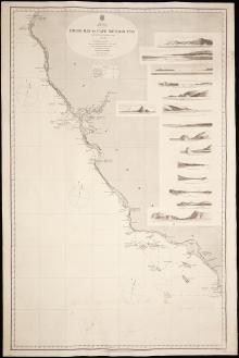
America's West Coast Diego Bay to Cape Mendocino was prepared by the British Admiralty from its original surveys done in 1855, and in this edition updated to Sept. 1865. The large scale, finely detailed representation of the California coast and islands is done by fine lined engraving, light beacons are hand colored with red with yellow flashes, and the coast is brought to life with scenic vignettes showing the coastline with pictorial perspective that include views from a ship at sea, harbor profiles and island profiles and terrain.

Alexander Hesler (1823 – 1895), the American photographer based in Chicago, Illinois took this photograph of Abraham Lincoln when he was a candidate for President of the United States. Hesler had Lincoln sit for this portrait in Hesler's Chicago studio in 1860.
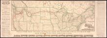
This New and Correct Map of the Northern Pacific Railroad is the Fall, 1883, November edition is the scarce first edition of this map that announces the completion by the Northern Pacific Railroad of the first northern transcontinental route from St. Paul, Minnesota through the northwestern territories to Portland, Oregon. The final spike ceremony for the line had been held on September 8, 1883 in Gold Creek, Montana with more work yet to be done.