
The Back Room
The Back Room presents both Americana and international materials. This inventory is a selection of rare, scarce and one of a kind materials published in the 18th, 19th and occasionally the 20th century. The Back Room also includes 19th century American wall maps, an area of special interest. The Back Room inventory will be updated frequently.
Displaying 41 - 60 of 88Pages
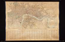
A New Map of London And Its Environs, 1829, likely published in late 1830 or in 1831 based on the range in the heading of the population chart on the map (1829-1830) is a detailed and historic image of London as a major city in transition from local industry to international trading powerhouse. A myriad of place names are labeled, streets and ways to the smallest route, the Thames and Greenwich Reach to Blackwell Reach and the Isle of Dogs. Factories stand by farmland. Fields and wetlands are delineated graphically. A windmill near the Cricket Grounds is shown.

This rare and early published survey of the Towns of Dorchester and Milton, Massachusetts was prepared and published to satisfy the 1830 order of the Massachusetts Legislature that each town in the Commonwealth have prepared a survey of its boundaries, roads and interior features. The 1831 Edmund J. Baker survey of these two towns straddling the Neponset River, which serves as the boundary line between them, conveys considerable geographic, economic and historic information about these early Massachusetts towns as of 1830 to 1831. Both 18th and early 19th c.
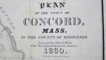
The John G. Hales Plan of the Town of Concord, Mass. in the County of Middlesex, 1830 is the first published survey plan of Concord. This particular edition of the 1830 John G. Hales Plan of the Town of Concord, Mass., published by Pendleton's Lithography of Boston, appeared in Lemuel Shattuck's book The History of The Town of Concord...From Its Earliest Settlement to 1832 that was published in 1835. There is an independently published version of this 1830 map that was also published by Pendleton's Lithography.

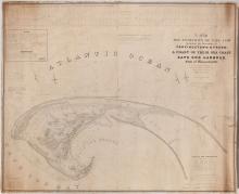
This monumental 1836 engraved survey of the extremity of Cape Cod showing the iconic curve of the Cape as it comes around and encloses Cape Cod Bay took three years and required 9 assistants to Major J.D. Graham U.S. Topographical Engineer in order to complete the work. This is the first government survey of the entire extremity of Cape Cod, that area of Cape Cod Bay and that portion of the Atlantic Ocean. In 1833, when the work was begun, Provincetown was an active maritime harbor and the civilian and military usefulness of this chart was considerable.

This rare, 1837 edition of the Map of Massachusetts, Rhode Island & Connecticut maps each of these New England states by county outlined in red, town or city in contrasting colors and locates the numerous large factories in operation in these three New England states in the early phase of America's rapid industrialization. Although New York is not shown on the map, New York city is. The map states at the top just below "New Hampshire", "this Map in addition to the information usually found on the best Maps, contains the Factories, Churches, Academies, Banks.

The Plan of the Village of Augusta, Maine, (the "Plan") from actual surveys by B.F. Pesham and published in 1838 is a scarce, first plan of the City of Augusta. The Plan is drawn at a large scale, 250 feet to the inch that permits the labeling of all buildings and occupied lands by the name of the land owner.

Edward Bailey, teacher, artist, craftsman, surveyor, naturalist, businessman, and man of many other skills drew this image of the town common of Holden, Massachusetts. It is a summer landscape and the tall trees surrounding the town common are in full leaf.
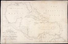
In this considerable 1840 undertaking J.W. Norie, Hydrographer published the latest version of his New General Chart of the West Indies and the Coast of America that captures the geography and political identity of what would five years later become the east coast of the American State of Texas. Florida's southern arm is shown. The commercially important islands of Cuba, Saint Domingo, Bermuda, Porto Rico and what is labeled "Central America" and the north coast of South America are also shown.
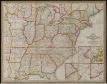
This fine, steel engraved map was engraved by J. H. Young (fl. 1817 to 1866) and published by Samuel Augustus Mitchell (1792 to 1868) who revised the map for two decades beginning in 1832. The map was published as a folding map to allow a traveler to put the map in his pocket, and take it out as needed to study while planning a trip or en route westward. The map was one of the most authoritative travel maps during this early period of America's westward expansion. The hand colored map is both decoratively colored and color coded as explained by the map's key.
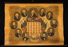
Portraits of the eleven U.S. Presidents as of 1846, the insignia of the current 29 states, including Iowa admitted December 28, 1846, Florida on March 3, 1845 and Texas on December 29, 1845. This is a full color lithograph that also presents George Washington at the top and center of the composition framed with a green olive wreath and overseeing a fierce American Bald Eagle who sits astride both the draped flags of the Union on poles decorated with gold braid and tassel, and a large red, white and blue shield bearing the insignia of the 29 admitted states.
Part I. A Brief History of the U.S. Exploring Expedition.

This scarce edition of Ensigns & Thayer's decorative broadside Ornamental Map of the United States and Mexico, undated, with its large inset map titled Map of the United States and Mexico flanked by two columns of the existing American states 1/, celebrates the 1848 United States victory in the two year Mexican-American War, settled by treaty granting America 55% of Mexico's prewar territory, including California and land that would become New Mexico, Colorado and an expanded Texas.2/ This colorful broadsheet presents Ame
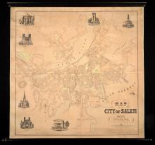
Henry McIntyre's elaborate, decorated survey map of the City of Salem in 1851 is a portrait of an already densely developed city. Seven large architectural vignettes convey the institutional strength of civic, business and religious institutions. City Hall is drawn in the top left corner, the Court House at the bottom center of the map built in 1841. The large facade of the Eastern Railroad Station marks Salem as a major shipping and transfer hub domestically and beyond in America's rapidly expanding railroad network and worldwide shipping.
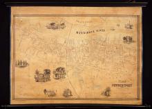
This rare wall map of Newburyport, Massachusetts is a survey and illustrated view of Newburyport in 1851. The plan of Newburyport is surrounded by vignettes of important homes such as the Old Balch Mansion, Mt. Royal, Residence of Mrs. S.W. Hale and the W.B. Bannister. Important public buildings and businesses are featured in vignettes including the Town Hall, the J. Currier Jr. Ship Yard that shows workers in a flotilla of small boats at work building a large ship. Carriages bringing guests are pulled up in front of the Merrimack House.
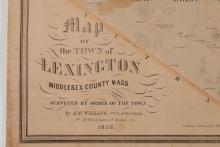
This rare 1853 wall map of Lexington, Massachusetts, was published in Philadelphia only seventy-seven years after the outbreak of the American Revolution.
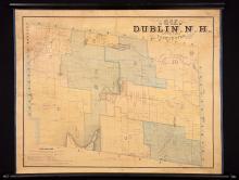
Thomas Fisk's Map of the Town of Dublin N.H., 1853 is one of the earliest if not the first survey map of Dublin, New Hampshire and it is extremely rare. The map's key explains the symbols used by Fisk to describe the lots, landowners, structures and occupants. They are unusual to this map. Dublin is a rural town with one of New Hampshire's iconic mountains, Mount Monadnock and this early map by Fisk provides a mid-19th century portrait of the town.
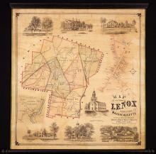
This scarce 1854 wall map of Lenox, Massachusetts surveyed and drawn by E.M. Woodford, with his characteristic architectural vignettes, fine lettering and detailed local mapping, presents a three dimensional view of this prospering Berkshire County shire town at mid-19th century. The Map of the Town of Lenox is illustrated with seven vignettes of local architectural scenes that enhance our understanding of how Lenox residents lived and worked.
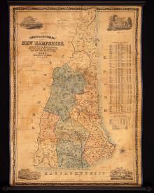
This is the scarce 1854 second edition, as noted on the map itself, of Jacob Dodge's comprehensive Township and Railroad Map of New Hampshire published locally in Nashua, New Hampshire. The first edition was also published in 1854. There are several subsequent editions of Dodge's map, including an 1856 edition, plus a "second" 1856 edition leading to some confusion as to the actual chronology of the editions. Railroad maps were often revised as railroad lines expanded and merged.