
-
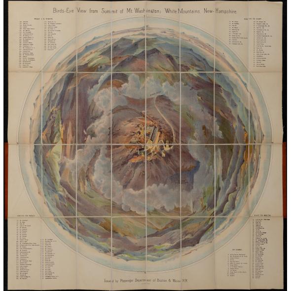 Bird's Eye View from Summit of Mt. Washington; White Mountains, New Hampshire. (c.1902) - First Edition, unique provenance
 -
 Boston, 1857, Charles Mottram engraver, after J.W.Hill, unique printer's proof edition
 -
 Plan of the Village of Augusta, Maine 1838
 -
 Map of The County of Bristol Massachusetts. From Actual Surveys 1858.
 -
 NEW-YORK.(nd) c. 1877- 1892 Bird's Eye View - Scarce
 -
 Nantucket From Monomoy Shore, Panorama c. 1910-1920, set of Three Panoramas by H. Marshall Higgins
 -
 Excerpts From Visions of Cody (Signed and numbered First Edition) by Jack Kerouac
 -
 A Pageant of the Pacific, 1940 - Complete Set (I.-VI) with Catalogue
 -
 The Atlantic Shore Line Railway and Connections. 1908
 -
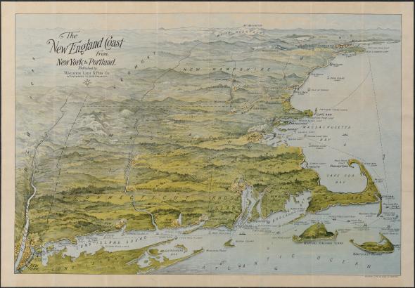 The New England Coast From New York to Portland.
 -
 Smith College Class of 1898, Memorabilia. [book] by Ruth Colburn Barnard
 -
 The City of New York, Fortune, 1939
 -
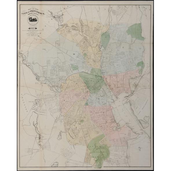 Map of the City of Providence, Rhode Island (1896)
 -
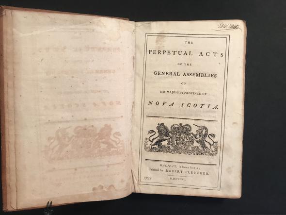 The Perpetual Acts of the General Assemblies of His Majesty's Province of Nova Scotia.1767 - First Edition
 -
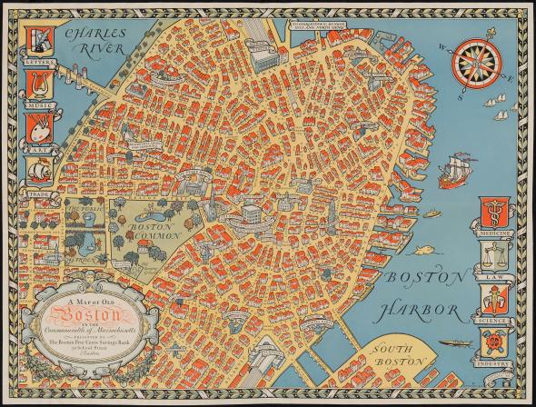 A Map of Old Boston in The Commonwealth of Massachusetts Presented by the Boston Five Cent Savings Bank 30 School Street Boston (1929)
 -
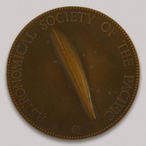 Astronomical Society of the Pacific Donohoe Comet Medal -Fred L. Whipple 1932
 -
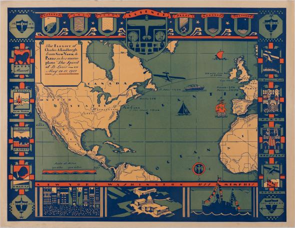 The Flight of Charles A Lindberg from New York to Paris in his monoplane "The Spirit of St. Louis" - on May 20-21, 1927
Upcoming Events
Original Antique Maps specializes in American and international maps of the 18th, 19th and 20th century published close to home and as far away as the Sandwich Islands. We also concentrate on Americana, including manuscript and photographic works. We offer our clients antique maps with an eye for the art, narrative and symbolism of the times in which a map was published. The philosophy of Original Antique Maps is that antique cartographic materials are also relevant to contemporary culture and ideas.
The Original Antique Maps inventory is organized in two parts: the "General Collection" of well regarded antique maps and prints; and "The Back Room" that offers rare, scarce or one of a kind materials. The inventory changes frequently.
The Back Room is also the place to find 19th century American Wall Maps - an area of special interest. Antique American wall maps hail from a time when art and knowledge were writ large and hung on the wall, either in public places or in the privacy of the parlor. Antique wall maps are remarkable paper tapestries.
Both the General Collection and The Back Room offer geographic and thematic maps, celestial charts, nautical charts, railroad maps, travel guides and urban bird's eye views to name a few. From time to time you may find broadsides with rich compositions of type fonts, imagery and text, illustrated 19th century children's books or 19th century scientific materials and from the 20th century boldly colorful pictorial maps of places both real and imagined. What unifies this ever changing collection is that each map, print or publication is a spokesman for its time, illustrating that moment when political boundaries moved, territories grew towns, inventors introduced new technology, political sovereignty shifted or a new cultural paradigm emerged.
Behold an antique map and grasp art, science and knowledge in your hands.