Skip to main content
Search form
Search
New Inventory
General Collection
The Back Room
Events & Articles
Events
Articles
Newsletter Signup
We Buy Maps
About
Contact
Indian Lands
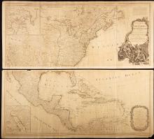
A New Map of North America with the West India Islands Divided According to the Preliminary Articles of Peace, Signed at Versailles 20 Jan. 1783, publ. 1786
Map of the Rocky Mountain Region Showing Forest Areas and Irrigation Ditches in 1885.
Main menu
New Inventory
General Collection
The Back Room
Events & Articles
Events
Articles
Newsletter Signup
We Buy Maps
About
Contact
New Inventory
General Collection
The Back Room
Events & Articles
Events
Articles
Newsletter Signup
We Buy Maps
About
Contact
Search form
Search