Skip to main content
Search form
Search
New Inventory
General Collection
The Back Room
Events & Articles
Events
Articles
Newsletter Signup
We Buy Maps
About
Contact
North America
A Map of the Province of Pensilvania Drawn from the Best Authorities 1756
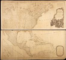
A New Map of North America with the West India Islands Divided According to the Preliminary Articles of Peace, Signed at Versailles 20 Jan. 1783, publ. 1786
Chart of St. Lawrence & Saguenay Rivers 1873.
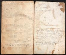
Manuscript Daybook and Diary, 1865-1867 (round trip) from New York City , around Cape Horn to San Francisco, California; to Portland, Oregon; to British Columbia; and to Anadir (Siberia), Russia,
Map of the United States of America with its Territories & Districts. Including also a part of Upper & Lower Canada and Mexico. [ First 1850 edition]
Mitchell's Reference and Distance Map of the United States 1845
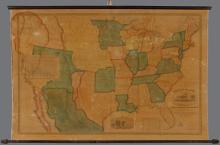
Ornamental Map of the United States and Mexico.
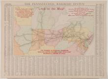
The Pennsylvania Railroad System "Look at this Map!", 1909
Main menu
New Inventory
General Collection
The Back Room
Events & Articles
Events
Articles
Newsletter Signup
We Buy Maps
About
Contact
New Inventory
General Collection
The Back Room
Events & Articles
Events
Articles
Newsletter Signup
We Buy Maps
About
Contact
Search form
Search