Skip to main content
Search form
Search
New Inventory
General Collection
The Back Room
Events & Articles
Events
Articles
Newsletter Signup
We Buy Maps
About
Contact
Geography
Pages
1
2
3
4
5
6
7
8
9
…
next ›
last »
MAUI HAWAIIAN ISLANDS. 1885.1903., Molokai, 1897, Oahu Hawaiian Islands, 1902, Kauai Hawaiian Islands 1903, HAWAII HAWAIIAN ISLANDS 1901,Lanai Government Survey 1878
"Africa", Phebe Varney, 1830, [Society of Friends], manuscript
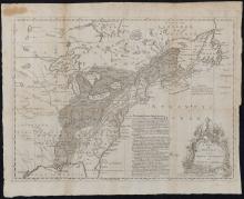
A Map of the British and French Settlements in North America, c. 1755
A Map of The Extremity of Cape Cod, 1836
A Map of the Province of Pensilvania Drawn from the Best Authorities 1756
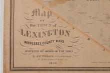
A Map of the Town of Lexington, Middlesex County, Mass. 1853
A Map of the Towns of Dorchester and Milton, 1831.
A Mapp of the Sommer Islands Once Called the Bermudas, c. 1627-1631
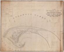
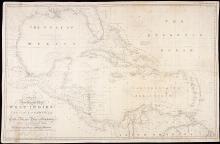
A New General Chart of the West Indies and the Coast of America, 1840
A New Map of Kentucky, 1857
Pages
1
2
3
4
5
6
7
8
9
…
next ›
last »
Main menu
New Inventory
General Collection
The Back Room
Events & Articles
Events
Articles
Newsletter Signup
We Buy Maps
About
Contact
New Inventory
General Collection
The Back Room
Events & Articles
Events
Articles
Newsletter Signup
We Buy Maps
About
Contact
Search form
Search