Skip to main content
Search form
Search
New Inventory
General Collection
The Back Room
Events & Articles
Events
Articles
Newsletter Signup
We Buy Maps
About
Contact
Survey
Pages
1
2
next ›
last »
MAUI HAWAIIAN ISLANDS. 1885.1903., Molokai, 1897, Oahu Hawaiian Islands, 1902, Kauai Hawaiian Islands 1903, HAWAII HAWAIIAN ISLANDS 1901,Lanai Government Survey 1878
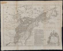
A Map of the British and French Settlements in North America, c. 1755
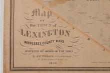
A Map of the Town of Lexington, Middlesex County, Mass. 1853
A Map of the Towns of Dorchester and Milton, 1831.
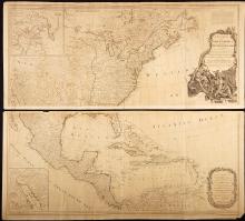
A New Map of North America with the West India Islands Divided According to the Preliminary Articles of Peace, Signed at Versailles 20 Jan. 1783, publ. 1786
Geological Map of the Lake Superior Land District in the State of Michigan
GEORGIA. (1808), Daniel Sturges, Surveyor General (Manuscript)
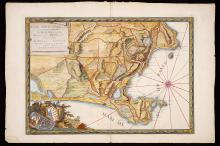
Icon Sinus Baiarum , 1772
Map of Boston for 1888.
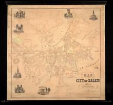
Map of the City of Salem, Mass. From An Actual Survey H.McIntyre 1851.
Pages
1
2
next ›
last »
Main menu
New Inventory
General Collection
The Back Room
Events & Articles
Events
Articles
Newsletter Signup
We Buy Maps
About
Contact
New Inventory
General Collection
The Back Room
Events & Articles
Events
Articles
Newsletter Signup
We Buy Maps
About
Contact
Search form
Search