Skip to main content
Search form
Search
New Inventory
General Collection
The Back Room
Events & Articles
Events
Articles
Newsletter Signup
We Buy Maps
About
Contact
History
Pages
1
2
3
4
5
6
next ›
last »
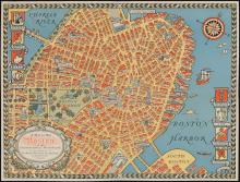
The COLOUR of An OLD CITY A MAP of Boston by Edwin Olsen & Blake Clark, artists 1926
MAUI HAWAIIAN ISLANDS. 1885.1903., Molokai, 1897, Oahu Hawaiian Islands, 1902, Kauai Hawaiian Islands 1903, HAWAII HAWAIIAN ISLANDS 1901,Lanai Government Survey 1878
A Map of Old Boston in The Commonwealth of Massachusetts Presented by the Boston Five Cent Savings Bank 30 School Street Boston (1929)
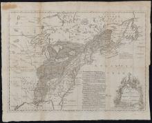
A Map of the British and French Settlements in North America, c. 1755
A Mapp of the Sommer Islands Once Called the Bermudas, c. 1627-1631
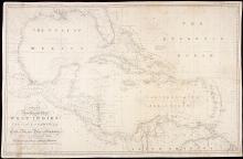
A New General Chart of the West Indies and the Coast of America, 1840
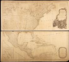
A New Map of North America with the West India Islands Divided According to the Preliminary Articles of Peace, Signed at Versailles 20 Jan. 1783, publ. 1786
A Pageant of the Pacific, 1940 - Complete Set (I.-VI) with Catalogue
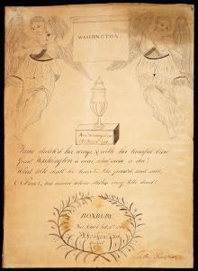
Abraham S. Fox, hand drawn Tribute and Mourning piece to George Washington, created at Roxbury, Free School Feb. 8, 1800.
Aldus Chapin Higgins Photo Album, 1923 A Ten Weeks Vacation Trip to Europe
Pages
1
2
3
4
5
6
next ›
last »
Main menu
New Inventory
General Collection
The Back Room
Events & Articles
Events
Articles
Newsletter Signup
We Buy Maps
About
Contact
New Inventory
General Collection
The Back Room
Events & Articles
Events
Articles
Newsletter Signup
We Buy Maps
About
Contact
Search form
Search